
Our
projects

PROJECT
Client
> Mace Construct
Sector/Market
> Infrastructure
Services
> 3D Laser Scanning, Geospatial Engineering, Scan-to-BIM, Construction Validation
Location
> Manchester, UK
In 2015, Manchester Airports Group announced the Manchester Airport Transformation Programme (MAN-TP), an eight-year, two-phase, £1.3 billion redevelopment initiative for Manchester Airport. The project set out to modernise and expand the airport’s infrastructure by enlarging Terminal 2 and adding a brand-new pier (Pier 2) to consolidate approximately 80% of passenger operations, enabling the closure of Terminal 1, and increasing from 20-25 million passengers total capacity to more than 30 million passengers each year.
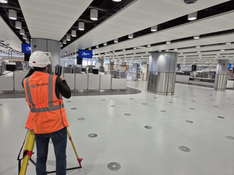
Mace Construct, a global construction business headquartered in London, oversaw the second phase of MAN-TP, which launched in January 2023. This included the refurbishment of the original Terminal 2 building and the construction of Pier 2. Early in the project, Mace Construct recognised that a structured geospatial approach would deliver meaningful improvements and help minimise delays. Murphy Geospatial, a Woolpert Company, was selected to provide geospatial management services for all construction-related geospatial activities on-site including:
- Change visualisation
- Construction validation
- Geospatial engineering services
- Laser scanning
- Scan-to-BIM
Project Outcomes
- 75% increase in cost savings achieved by resolving issues digitally rather than on-site.
- Improvement in installation accuracy from 60% to over 90% through precise geospatial data and construction validation.
- Approximately 5% reduction in overall extensions of time and project-specific extensions of time.

Geospatial Management Strategy
Murphy Geospatial’s primary goal throughout was to provide Mace Construct with the oversight and assurance that the project was constructed in accordance with the design.
Mace Construct was supplied with a high-quality as-built dataset, fostering a right-first-time culture to support trade partners and the management team in delivering the design intent. This continuously updated digital model served as a single source of truth, improving installation accuracy and overall project precision, while promoting compliance and high-quality installation across all on-site work.
As the dedicated geospatial lead, Murphy Geospatial liaised with subcontractors and Mace Construct management, attending coordination meetings, responding to setting-out requests, and delivering live dashboards and weekly reports.
Murphy Geospatial also implemented a structured construction validation program, which included:
- Continuous capture of point cloud data across the entire site using high-definition laser scanning.
- BIM comparisons to detect deviations from design models in both Terminal 2 and Pier 2.
- 360° site photography and deliverables for ongoing stakeholder updates.

Overcoming Challenges Throughout the Project
Murphy Geospatial’s role was to prevent these opening-related issues from reaching the physical environment by resolving them earlier in the digital one. Using precise geospatial data and construction validation processes, the team identified deviations before they caused issues on-site, preventing knock-on effects that could lead to delays and time-consuming rework.
Resolving issues in the digital environment is significantly faster, less costly, and less disruptive than stopping a crew on-site. In the case of MAN-TP, one of the project’s architects was based in London, almost four hours away, meaning each unnecessary site visit resulted in lost time, additional travel costs, and increased carbon impact.
Murphy Geospatial overcame several challenges during the work on phase two of MAN-TP, including:
- Fast-paced schedule and multiple contractors: Mace Construct needed to coordinate a large supply chain of specialists while ensuring that simultaneous workstreams across Terminal 2 and Pier 2 remained aligned and on schedule. Murphy Geospatial provided high-quality geospatial data and analysis that improved decision-making, supported contractor management, and helped identify recurring issues early.
- Working in a live, congested environment: Throughout the project, Terminal 2 remained highly congested, with passengers continuously boarding and disembarking. Murphy Geospatial and Mace Construct implemented several solutions, including a dedicated shuttle system to transport workers directly between Terminal 2 and Pier 2, as well as scaffolding to keep the live passenger tunnel operational and free of construction materials and personnel.
- Incorrectly sized and positioned openings: Contractors often adjust openings to suit immediate requirements, creating knock-on effects that can hinder subsequent trades. Murphy Geospatial used precise geospatial data and construction validation processes to identify deviations before they caused on-site issues, preventing costly delays and time-consuming rework.

Delivering Quantifiable Value and Outcomes
Murphy Geospatial’s comprehensive geospatial management strategy delivered the following results:
- 10 to 12% reduction in on‑site errors.
- 18 to 20% reduction in the cost of claims and disputes.
- Approximately 5% reduction in overall extensions of time and project-specific extensions.
Below is a six-month sample of results from Murphy Geospatial’s construction validation programme, which followed a weekly scanning cadence with next-day turnaround, alternating between Terminal 2 and Pier 2:
- More than 6,000 issues identified, including over 4,000 within the Terminal 2 redevelopment and more than 2,000 in Pier 2.
- Project completion status during validation: approximately 90% for Terminal 2 and approximately 75% for Pier 2.
- Improvement in installation accuracy from 60% to over 90%.
- 75% increase in cost savings achieved by resolving issues digitally rather than on-site.
Additionally, for its exceptional geospatial management work at Manchester Airport Terminal 2 and Pier 2, Murphy Geospatial was selected both as a finalist for the Innovation in Airport Engineering award at the Airports New Civil Engineer Airport Awards 2026, and won for the Supplier of the Year.
Client Testimonial
“Murphy Geospatial’s geospatial management and digital construction verification solution fundamentally enhanced our understanding of project progress and the accuracy of critical element placements on the Manchester Airport Terminal 2 and Pier 2 project. The robust framework for conducting accurate progress surveys, performing near real-time comparisons with BIM design models, and identifying potential clashes enabled Mace Construct to make informed decisions throughout the project. This approach led to a measurable reduction in rework and provided a tangible means of fostering a ‘build-right-first-time culture’.
Guy Fowler, Director – Infrastructure, Mace Construct
Contact
For more information on this project or for more information on how we can support your next project, please email info@murphygs.com or call us on +44 (0)192 362 4800