Our
projects
PROJECT
Client
> Trinity College
Sector/Market
> Infrastructure
Services
> Subsurface Surveys, Subsurface Investigation & Geophysical Surveys
Location
> Dublin, Ireland
Project summary
Murphy Geospatial, a Woolpert Company was tasked by Trinity College Dublin to investigate a previously undocumented underground structure discovered after an uprooted tree exposed a void on college grounds. The objective was to map the extent and condition of the suspected historic cellar or vault using non-invasive methods that would preserve the integrity of the heritage site.
To meet the project’s goals, Murphy Geospatial deployed a high-speed 3D Ground Penetrating Radar (GPR) array to capture high-resolution data of the upper subsurface, followed by Electrical Resistivity Tomography (ERT) to explore deeper features. This integrated approach enabled the creation of a high-density 3D dataset, which was processed into a detailed visualisation of the underground structure.
The final deliverable—a comprehensive AutoCAD drawing—successfully delineated the extent of the void, meeting the client’s expectations. Based on the results, Trinity College proceeded with a follow-up utility survey to refine the interpretation and ensure safe excavation for any future archaeological work. The project demonstrated Murphy Geospatial’s ability to deliver precise, non-intrusive geospatial insights in sensitive and historically significant environments.
The brief
A few years ago, an uprooted tree on a site owned by Trinity College Dublin revealed a previously undocumented underground void—believed to be part of a historic cellar or vault. This unexpected discovery prompted initial archaeological interest, but the full extent and configuration of the structure remained unknown.
Recently, Trinity College’s Department of Archaeology engaged with Murphy Geospatial to carry out a detailed, non-invasive investigation of the site. The objective is to accurately map the subsurface features and determine the spatial extent and structural condition of the underground vault, without disturbing the surrounding heritage landscape.
Our work
The primary requirement was to identify potential voids, tunnels, catacombs, or vaulted structures at depths of up to 3 metres, using a rapid and non-invasive approach. While no formal specification was provided, the solution needed to deliver high-resolution subsurface data efficiently and with minimal disruption to the site.
Murphy Geospatial proposed a two-phase geophysical strategy:
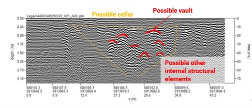
- High-Speed 3D Ground Penetrating Radar (GPR) Array: This was deployed to capture a detailed, high-resolution dataset of the upper 2 metres of the subsurface. The GPR array enabled rapid coverage of the site while maintaining the spatial accuracy required for archaeological interpretation.
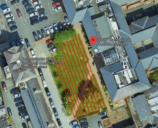
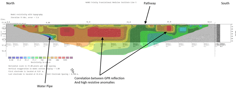
- Electrical Resistivity Tomography (ERT): Multiple parallel ERT lines were acquired to investigate deeper subsurface features beyond the GPR’s effective range. This method also provided dense spatial coverage, enhancing the ability to detect and delineate any deeper anomalies or structural voids.
This integrated approach ensured comprehensive coverage of the site, balancing speed, resolution, and depth penetration to meet the project’s investigative goals.
The above-mentioned technologies and solutions were used to generate a high-density 3D dataset, the processing of which produced a high-resolution image.
Results
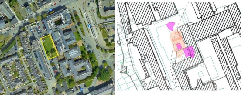
The primary deliverable was a detailed AutoCAD drawing with integrated interpretations from both the Ground Penetrating Radar (GPR) and Electrical Resistivity Tomography (ERT) datasets. This drawing delineated the spatial extent of the suspected underground structure, providing a clear and actionable visualisation of the subsurface conditions.
To find out more about subsurface surveys click here.
Contact
For more information on this project, please email info@murphygs.ie or call us on +353 (0)45 484 040.