
Project summary
Installation of primary and secondary control points along 130km of the M1 and M6 motorways.
The brief
Murphy Geospatial was contracted by Blom Aerofilms to install primary and secondary control points along 130km of the M1 and M6 motorways as part of the Highways Agency’s ‘Smart Motorway Programme’.
The challenges
Working in a high-speed environment always presents itself with challenges and risks. We worked collaboratively with the area teams and traffic management providers to ensure that a safe work system was put in place so that the works could proceed.
The teams worked really hard to ensure that we maintained consistency in the coverage achieved per day. While this was technically an easy survey to complete, while being repetitive, any mistakes could cause delays and cost overruns. However, the team completed the task faultlessly and achieved excellent accuracy below the expected tolerance set.
Our work
Two PGMs were installed both over and under each motorway bridge to form a baseline from which subsequent surveys could be carried out. These two PGMs were surveyed with simultaneous static GPS observations of around 1 hour.
Secondary control was installed and surveyed at intervals of 50m along the back edge of the hard shoulder for the entire length of the route in both directions, and at 50m intervals along any roads crossing the motorway as described above. This was typically a total distance of 100m per bridge.
These secondary points were installed with a Hilti type nail and marked with spray-painted opposing squares so that they could be picked up and visible within the mobile mapping scanned data.
Non-contact measurements, taken from the previously installed baseline PGM control on the over bridges, were observed to coordinate a number of these points.
The survey data was then adjusted to ensure errors were distributed correctly and evenly.
Our team
The team started working on the project in November 2014 and efficiently completed the survey across the 130-kilometre road in January 2015 as planned.
Results
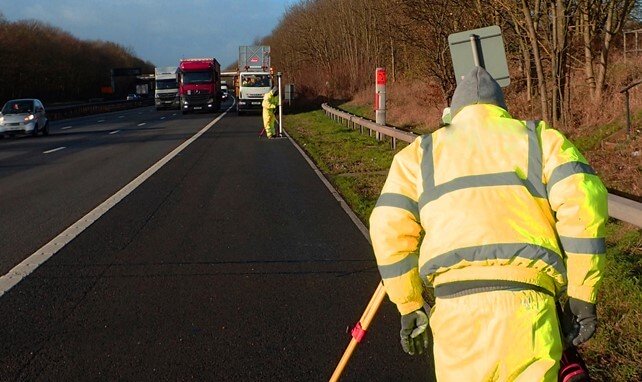
A team of three surveyors were mobilised to work on the hard shoulder with an Impact Protection Vehicle to the rear and a second vehicle ahead of the team.
One member of the team used a measuring wheel to locate the next 50m location before installing and spray painting the 200mm x 200mm opposing squares.
The remaining two team members used a digital level and levelling staff, which was fitted with a customised bracket enabling a GPS antenna to be fixed over the centre of the staff. This allowed us to take an RTK GPS measurement at each location to provide the X & Y coordinates while the levelling provided the height to increase accuracy.
Several GPS measurements were taken at each location and averaged to obtain an accurate position. This method was also chosen because of the limited space available to work in ahead of the IPV.
